

A big birthday for my husband was approaching, and as we considered our options about how to celebrate, the one thing we knew was that we wanted to be with our family. So, we settled on revisiting my husband’s decades-past college spring break destination – Bermuda. And we decided to get there on an NCL cruise from NYC. It was a very different kind of trip for us.
Overall, we had some great family time and moments we will treasure forever. The NCL Aqua (a one-year-old ship) was great for the kids and not so great for the adults. I guess I’ve been spoiled by travel on smaller ships with more attention to detail.

A New York State of Mind
It was a nice start to be back in NYC to catch our cruise. We arrived by train at Penn Station and selected a hotel within walking distance of the New York Port on the Hudson. Ink48 was just OK; one of our rooms wasn’t ready at check-in, but rooms were comfortable, and the location was convenient. BTW – after the cruise, we departed from Penn the same day as the Taylor Swift wedding. In case you don’t know, Penn Station is under Madison Square Garden. Despite the street closures and general chaos, we didn’t have any issues.


That evening we all had fun at Jamie Allen’s AMAZE magic show. You have to be at least five to attend, and our grandson proudly made the cut. Allen’s combination of narrative and magic wove an interesting personal story, and his tricks were truly amazing and entertaining.

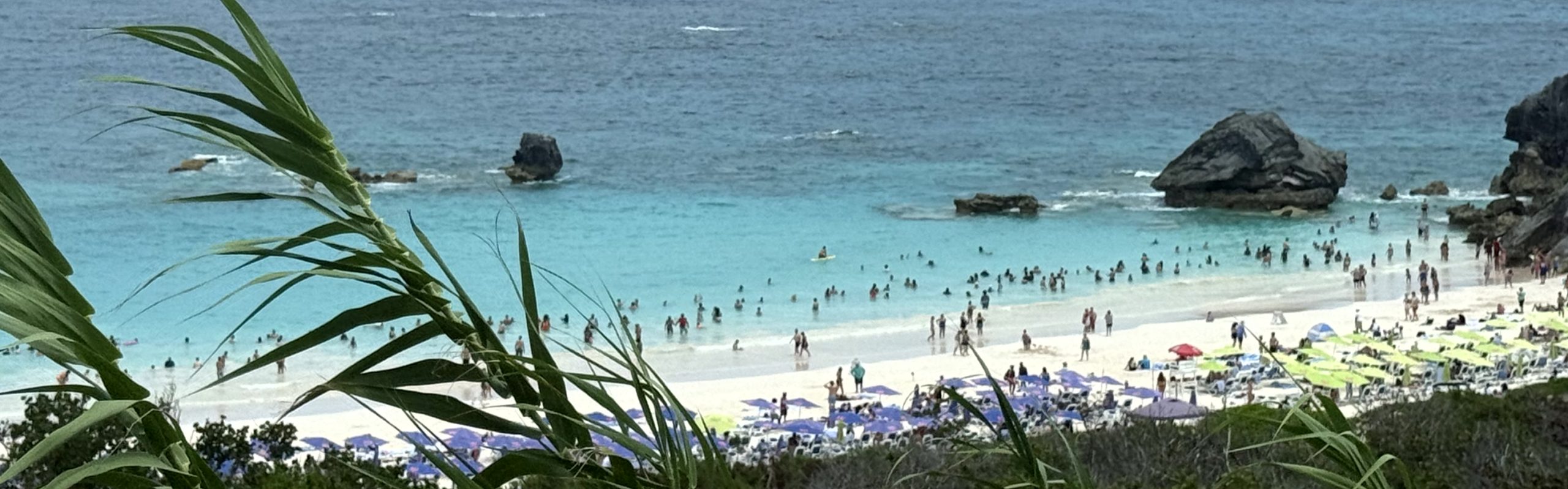
Three Generations in Bermuda

We really enjoyed our three days in Bermuda. The ship docks all the way at the tip of the 21-mile island at the Royal Navy Dockyard. It was easy for my daughter and her family to take a shuttle to the famous Horseshoe Bay Beach, and NCL does offer a complimentary ferry to St. George (a fact not well publicized in advance).
For $5, you can take a 20-minute ferry ride into Hamilton, which is what we did (exact change or buy a token in the ferry office). My husband and I spent a nice day in Hamilton. We had a tasty lunch at the breezy, open-air 1609 restaurant at the Hamilton Princess, and then, with the help of their kind and capable Bell Captain, secured a car and driver to see the island and revisit some special spots.


After a brisk morning walk, we relaxed in Victoria Park, Hamilton’s first public park dating from 1889.
Of special note, the cottages where my husband stayed – Mizzentop, were still there and had clearly been well-maintained. But sadly, his recollection of partying at the resort on Elbow Beach will have to remain just a memory. The resort is slated to be torn down, and its beach access has been closed. There was one narrow access point to the Beach, which was unsurprisingly not at all crowded on this day.

I really enjoyed getting to see this beautiful island with its pastel homes and British Colonial style. It was clean and safe, and we felt very welcome (even though we were off a cruise ship!)


The only excursion we took through the ship was a glass-bottom boat/snorkel trip billed as kid-friendly. It was kid-friendly until our granddaughter saw an eel and had a bit of a meltdown – but the very nice Captain Zoe helped calm her down. We were not too impressed with the coral reef or wreck we saw, but that’s probably because, being from Florida, it was not an unusual sight.

A hit for the kids was a visit to Dolphin Quest and a chance to spend some time with dolphins Juniper and Ely. It was pricey but well worth it. I included the prepaid photo package. I feel like photos are always the best souvenirs of any trip, and we got 147 pics! It’s an impressive operation.
Back to My Thoughts About the NCL Aqua

We chose regular connecting cabins vs the more exclusive option, The Haven. It seemed like a bad idea to take a 5 and 7-year-old into that presumably quieter area. The ship did not have family-style options. The cabins had good storage for two, but a challenge for four. They did have unusually comfortable, well-padded seating on the verandas.


The kids’ club, Splash Academy, for their age group was terrific, and they loved going. The miniature golf, game area, and arcade were all huge hits with our grandkids. The small pool and baby-oriented splash areas were not. Fortunately, the kids forgot about the winding water slide; they were under the 48” requirement to go (even with an adult). One rainy sea day proved to be a challenge, and we were thankful for the Splash Academy.
There is one kids’ menu, and it’s the same in every venue onboard. If kids eat from that menu, there is no charge for them in the specialty restaurants. That would be if you could actually book the specialty restaurants. We could not book any we wanted (even though we had paid). I guess the lesson here is that you need to book ASAP. Among our group, we finally were able to try two and also ordered from the steakhouse menu while dining in the main dining room. All were very uninspiring. The best thing I had on the ship was the hot fudge sundae in The Local.

The venues on board don’t seem to be able to accommodate the number of passengers. You can’t reserve a table in one of the two main dining rooms, and on the final night of the trip it was an hour wait for a table. Dining and bar areas always seemed congested, and getting a seat was a challenge. Staff at the included Indulge restaurant, in which diners order from food-hall-type options on a computer screen, seemed confused by our request for a kids’ menu.
The cabin bathroom was very well done with a large shower and plenty of storage. But no amenities such as conditioner or body lotion (only shampoo and body wash). Bring your own because they don’t sell any in the on-board shop either. Prepare for individual bottles of water that are $4.50 each. We could get a cocktail with our package, but not a bottle of water.
It was really annoying that you had to pay for the on-board Wi-Fi service to use the ship’s app. In my experience, ships’ apps work independently of the paid service, so you can get news info and often even communicate with other travelers.
Crew members were nice, but seemed overworked. Our attendant had 24 cabins to handle, alone. As a result, there is no evening turndown service and often late clean-up.
In summary, this was a great family trip and a disappointing cruise for the adults in our group. We chose this ship because of the itinerary. Next time for the family, it will be Disney or Celebrity.


We couldn’t pass up a chance while in eastern Pennsylvania, for a quick visit to the Amish countryside. Even though it was a Sunday, we were still able to enjoy a lovely carriage ride surrounded by healthy-looking farms.
We chose Aaron and Jessica’s Buggy Rides on Old Philadelphia Pike in Bird-In-Hand. Learning they’ve been in business for over 25 years and are family-owned made our decision easy. They are located on the property of Plain & Fancy Farm, an original Amish farm, operated by Amish, Mennonite, and Brethren families since 1959. Another interesting fact: the farm’s ancestors came to America in 1626.
Because it was a Sunday, we had a non-Amish driver, and the shops and most tours were not available. The drive was about 20 minutes on quiet roads and was a perfect outing for my 5 and 7-year-old grandkids.

Our horses were two big boys – Diamond and Jake. And we got to sit right up front, next to the driver, with the kids on stools in front of us. Another family rode in the back.
The pastoral setting would’ve made a perfect painting.
And, can you guess what the kids loved best (and what was immediately reported to their friends later that day)? They had an up-front and personal show when the horses pooped, not once, but three times!


We are back in North Carolina for the summer. On the long trips back and forth, I love to find interesting sites to visit along the way. It seems to make the transit a bit more worthwhile.
A quiet stop off I-95 reveals centuries of Lowcountry history
This trip, we spent the night en route in Yemassee, SC. It was just a few miles from I-95 in Beaufort County to the site of a beautiful red brick church ruin dating from the days before the Revolutionary War.

The Prince William’s Parish (Anglican) Church was built in the 1740s in the Greek Revival style as an outpost of the mother church in nearby Beaufort. Some reports say it’s the first Greek Revival building in the US; all agree it was at least one of the earliest. The land was donated by the Royal Governor of South Carolina, Col. William Bull, who owned the large adjacent plantation. It is most often referred to as “Sheldon Church,” in honor of the Bull ancestral home in England. It was karma that, on this lovely, cool morning, we met the groundskeeper who was trimming for a scheduled graduation ceremony. As groundskeeper, he had been given a box of documents to store, including many of the church’s historic records.

The morning light filtered through the impressive moss-draped oak canopy as he enlightened us about a more accurate history than many of the reported stories. It is undisputed that the church was burned by local Loyalists during the Revolutionary War and rebuilt in the 1820s. This is Swamp Fox territory, where the famous revolutionary Marion Francis ruled, and it was believed he stored arms and ammo on the site.
Separating myth from fact at one of South Carolina’s most haunting sites
When research was done to place the site on the National Register of Historic Places, letters from Confederate soldier, Milton Leverett, a Bull family descendant, were discovered. Those letters recorded details about what happened to the church in the years during and after the Civil War. Stories of being burned by Sherman were not accurate, according to the letters. Sherman was directed to burn the South – but not the churches. The letters attributed the destruction of the church to being dismantled by local black and white families and repurposed for housing in the severely devastated region. People simply made do with what they could.


The 3.5-foot brick walls stood, overtaken by wild growth, untended for more than 150 years. Since the 1920s, the parent church, St. Helena’s in Beaufort, occasionally held an open-air service on the site and, in 1937, the Colonial Dames erected a plaque on the ruins (with incorrect info). It was otherwise overlooked and forgotten until a local resident took on the task of having it memorialized with the National Register of Historic Places in 1970. Today, an updated historic marker along Old Sheldon Church Road reflects the more accurate history.
Many of the scattered historic grave markers on the church grounds have also been restored.


Visiting the site is free and open to the public (still privately owned by the Anglican Church in Beaufort). Your GPS should get you to the spot, but don’t blink, or you might miss the historic marker and entrance. There is an area for parking across the road. You are in the Lowcountry, so bring bug spray for most times of the year.


We covered a lot of territory on this trip, and our time in Marrakesh was no exception. Since this is my final post for this series, I’m going to round up a variety of highlights from several days. Enjoy a review of a little art, some gardens, a lot of history, and some relaxation.
YSL Majorelle Gardens
In 1923, artist Jacques Majorelle created his dream home, complete with a villa and beautiful gardens. After his death and years of neglect, Yves Saint-Laurent and his partner Pierre Bergé bought the property in 1980 and undertook a total restoration. Today, there are 400 varieties of palms and 1,800 species of cactus, as well as a memorial to YSL and the Pierre Bergé Museum of Berber Arts.
It was really a lovely spot, but these days, very crowded. You must have reservations and then be prepared to stand in a long queue to enter in smaller groups. Security along the planned route keeps everyone moving and under control. There are no photos allowed in the museum. Despite all that, I am still glad we got to see it.


Back to Antiquities
We covered various landmarks during our stay here, and a few are featured in the photos below. Not pictured are the Koutoubia Mosque and La Palmeraie. La Palmeraie (the water-fed palm grove oasis mentioned in previous posts) is huge here. The portions we saw look very bedraggled. Scraggly palms, many with missing fronds, and dozens of camel concessions ready to take tourists for rides. It did not look appealing.
At this point in the trip, we’ve seen a lot of UNESCO sites that honestly began to blur together. Marrakesh was crowded, and it was a bit more difficult to really enjoy the details that make these locations so special. Over the hundreds of years, some sites were built, torn apart, pieces moved, and rebuilt by later rulers – it’s complicated.


A necropolis since 1145, the tombs of the Saadian dynasty date from the late 1500s. Unrecognized and hidden from view for two centuries, they were uncovered and made accessible to the public in 1917.


A Private Collection
The Riad Kniza , located in the Medina, was our home while in Marrakesh. It was a great example of an innovative owner who combined several historic riads into one, uniquely lovely historic property.


I was wandering around the Riad’s public areas, taking pictures of the wonderful paintings, when a gentleman stopped and introduced himself. It turns out it was the owner of the property, Mohamed Bouskri. I knew he had a private museum and had not yet seen it, so I jumped at the chance when he offered to take us himself. He and his wife were antique dealers, and his collection, gathered in honor of his parents, is wonderful, well-curated, and beautifully displayed and labeled. Unlike the Berber museum at the Majorelle Gardens, his signage includes English. I’m showing just a few examples here. BTW, he also has a great gift shop with antiques and jewelry his wife makes using antique pieces, as well as a boutique run by his daughter.


The Iconic Hotels: La Mamounia & Royal Mansour


This adventure is in the books. We enjoyed our time in Morocco and felt very welcome here. I confess, it was hard to keep my eyes open during the three-hour drive back to Casablanca to catch our flight home. Til next time.


")
")
")

")


