

Today, we explored the rural life in Chile’s Chiloé district. Known as the Lake District, there are 40 islands here, and 35 are inhabited. There is a lot of fascinating history here, from the Mapuche indigenous name Chiloé, meaning “place of seagulls”, to the 15 UNESCO churches in the area, and much more. I will merely scratch the surface. From the port of Castro, we tendered in from our ship to meet our excellent, informative, and entertaining guide, Cecilia. We started with an early visit to the local market, one of our favorite things to do. The produce looked amazing. I was blown away by the size of the garlic cloves, which were sold individually and were the size of one of the large garlic heads typical in our groceries. The fish and shellfish assortment was wonderful. We even tried out some of the delicious local cheese.


A Rescued Town: Preserving the Soul of Chiloé
It was another gorgeous, sunny day, about 10 degrees warmer than the previous. A scenic drive en route to the Rilán Peninsula rolled through farmland, estancias, and by some substantial-looking homes. We eventually arrived at the restored settlement of Wuelton. The 150-100-year-old wooden buildings were moved here in 2015 and restored to showcase the Chiloé culture. The setting was used in a movie that was the catalyst of the project. Eleven of the original 17 survived the move and restoration. This village-museum is a showcase for how families lived, cooked, made textiles and baskets, fished, studied, and worshiped. It was a good way to study the various types of wooden shingles used to decorate the exteriors.


For me, it was an obvious comparison to the collection of U.S. log cabins at Hart Square Village I visited 6 months ago. Although Hart Square Village (near Hickory, NC) has many more buildings, they are from the same era and show many similar facets of life. It’s so interesting to consider how people live in the same timeframe in different cultures.
BTW, along the way, we tried more local cheese, local drinks, crab legs, and salmon ceviche – all delicious.
Stilt Houses on the Edge, Castro’s Colorful Waterfront

Back on the waterfront, we boarded a small open boat, the Nancy III, to head over for a closer look at the charming Castro stilt houses (called palafitos). This style of architecture is located in several areas of the town, and many are quite old; others are new, sometimes replacing those that have collapsed into the fjord. Originally filled with fishermen, today many house boutique hotels, private homes, shops, and cafes.


At this point, it was clouding up, and time to call it a day, and the Nancy III delivered us directly back to our anchored ship, the Azamara Quest. Gorgeous weather, cultural enrichment, exceptional scenery, historic preservation, and even some tasty treats combined for a perfect adventure!


Puerto Chacabuco is the marine gateway for the Aisén region. And this has to be one of my all-time placename favs. Who doesn’t love to say Chacabuco!
It is also a delightful spot to visit, and we had a beautiful sunny day in the area. We arranged a tour with a local company (Puerto Chacabuco Tours) and, after anchoring in the fjord, tendered in and headed out with a few others from our ship.
Initially, I wasn’t clear why it was called the “Ice End” tour, but now I know it’s a play on the pronunciation of the nearby town Puerto Aysén. Because we left early, the temps were still in the low 40s, and fog had settled in the valleys for a very mystical appearance. Our first stop was the lovely Coipos Lagoon. It was nice to hear the distinctive call of the Chucao birds. The paths suffered from neglect, but the vista was pristine.

Nice to See Green
This is the most sparsely populated area of Chile, about the size of Tennessee, with just over 100,000 residents, most in the capital, Coyhaique. Puerto Chacabuco only has 1,200 residents. The region includes the Northern and Southern Patagonian Ice Fields (largest after Antarctica and Greenland), and we saw lush fields, wetlands, tall forests, lots of evergreens, and rugged, forested granite mountains. It’s an agricultural area, and there were plenty of cows, horses, sheep, hogs, and lots of big, fluffy dogs.

The privately owned Bahia Acantilada Park sits on a beautiful bay with a view of the Andes range. Park amenities left a lot to be desired, needing some serious maintenance. Back in Puerto Aysén,our driver literally stopped the van to chat with the mayor (everyone knows everyone here) and lodge a complaint about the faulty generator and lack of baño lights – lol.
We saw a number of rivers, including the well-known Rio Simpson, popular with fly fishermen, and Mañihuales. These and other rivers all flow into one another, ending up in the Pacific.

Falls & a Historic Bridge
A big attraction here is the Cascada la Virgen falls. I think everyone visiting the area was checking this out, and the small parking lot was jammed. At the shrine, there were copious flower arrangements and prayer donations. But as of this writing, I do not have a good explanation why this is considered a holy site.

My favorite stop of the day was a visit to the area’s oldest bridge, dating from just 1919. No longer passable by vehicles, it’s still (relatively) safe for pedestrians. Consistent with maintenance needs in the region, be prepared for missing boards, broken boards, unsecured boards, and unevenly spaced boards. In short, an accident waiting to happen. But I loved the middle-of-nowhere setting and beautiful river. Birds, including Ibis, were abundant.
Our captain has hoisted up the ship’s anchor 85 meters, and we are back sailing the fjords.


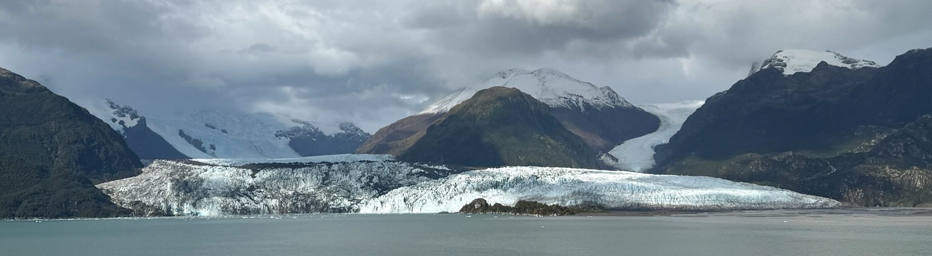
The amazing Amalia Glacier, at the end of the Sarmiento Channel in Chile’s Bernardo O’Higgins National Park. Rapidly retreating, it’s part of the Southern Patagonian Ice Field.
As the clouds shifted, once again, we were blessed with a rainbow.


View over Punta Arenas 
Trinidad
We are currently sailing through the inside passage of Patagonian Chile. Calm and scenic, it’s also cloudy and rainy, and I’m happy we don’t have to go anywhere outside today. I’m happy to simply stare at the passing scenery as it goes by. It’s a good time to catch up on a post about yesterday’s activities.
The Strait of Magellan

When Magellan sailed the Trinidad around the tip of South America and along its western coast, he went ashore at this sandy spot, securing its future for the next few centuries. Punta Arenas (Sandy Point) would become an important and thriving port until the early 20th century and the advent of the Panama Canal.
Today, it’s a community of 120 thousand that has suffered many rough economic times since the port’s prominence diminished. Its colorful buildings make it easier for families to find their homes during the winter months when deep snow blankets the area. Corrugated steel building material helps drain the melting snow in the spring. Winds are so strong here, city managers have ropes tied between light poles so pedestrians can hold on while walking between shops. Thankfully, on this day, the winds were calm.

Fuerte Bulnes 
We journeyed to the Parque del Estrecho (aka Magellan Strait Park) with its Fuerte Bulnes National Historic Monument and museum, located about an hour out of town. We drove the coastal road, passing dozens of beached fishing boats waiting for the fishing season to begin (King Crab season is July 1 – November 30). It’s a narrow and rocky-looking, low coastline, littered with a few of the many shipwrecks for which the area is famously known. In one section along the water’s edge, there are hundreds of small graves, which turned out to be a dog cemetery.
With a former geography professor as our guide, we had a terrific experience focused on the geography, history, environment, flora, and fauna. The historic fort was originally established in1843 and rebuilt a hundred years later. It includes a church, captain’s quarters, jail, powder magazine, stables, and barracks.


We took a really enjoyable walk through the park, learning about the plants along the trail, eventually arriving at Puerto Famine. It was a beautiful setting memorializing a horrific mass casualty in 1587, of an early attempt to establish a Spanish colony. The settlers perished from starvation and the harsh climate. There was only one survivor, eventually found by English Captain Thomas Cavendish, who named the site to memorialize his tragic discovery. On this day, we were welcomed by a spectacular rainbow stretching across the horizon.
The museum was small but had interesting displays about the famous sailing vessels during the age of discovery, the history of colonization, and a lovely photo display about the region’s glaciers.
A light misty rain began to fall as we headed back down the coast to our floating home away from home on the Azamara Quest.


")
")
")

")


